
Ortho-Mosaic
Image Processing
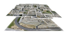
We utilize Pix4d and senseFly proprietary software to orthorectify a series of aerial photographs into a single ortho-mosaic image. Our ortho-mosaic images are taken with an average of 3 to 5 cm ground sample distance.
Point Cloud
Generation

Point clouds are a series of dots or points placed on a plane. The points are given elevation based on the Digital Elevation Model data to produce full, colored point models of the imaged area.
Digital Elevation
Modeling
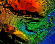
We utilize Pix4d and senseFly proprietary software to produce Digital Elevation Models (DEM) with an accuracy of under 10 cm. DEM’s can be used to generate stockpile volume estimations and are well suited for many other applications.
Get A Quote
For more information on Data Processing, contact info@3daerial.com